مقاطعة ستافورد، ڤرجينيا
Stafford County | |
|---|---|
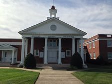
 The Stafford County Courthouse in October 2013. | |
 الموقع ضمن ولاية Virginia | |
 موقع Virginia ضمن الولايات المتحدة | |
| الإحداثيات: 38°25′N 77°27′W / 38.41°N 77.45°W | |
| البلد | |
| State | |
| تأسست | 1664 |
| السمِيْ | Staffordshire, England |
| Seat | Stafford |
| أكبر community | Aquia Harbor |
| المساحة | |
| • الإجمالي | 280 ميل² (700 كم²) |
| • البر | 269 ميل² (700 كم²) |
| • الماء | 11 ميل² (30 كم²) 3.9%% |
| التعداد | |
| • Estimate (2017) | 146٬649 |
| • الكثافة | 545/sq mi (210/km2) |
| منطقة التوقيت | UTC−5 (Eastern) |
| • الصيف (التوقيت الصيفي) | UTC−4 (EDT) |
| Congressional district | 1st |
| الموقع الإلكتروني | staffordcountyva |
مقاطعة ستافورد إنگليزية: Stafford County هي إحدى المقاطعات في ولاية ڤرجينيا في الولايات المتحدة.
الجغرافيا
Major bodies of water
Adjacent counties and independent city
|
|
الحكم والسياسة
| Position | Name | Affiliation | First election | District | |
|---|---|---|---|---|---|
| Supervisor | Wendy Maurer | Republican | 2015 | Rock Hill | |
| Supervisor | Cindy Shelton | Republican | 2018 | Aquia | |
| Vice-Chairman | Mark Dudenhefer | Republican | 2018 (also served 2005–2011) | Garrisonville | |
| Chairman | Gary Snellings | Republican | 2009 (also served 2001–2005) | Hartwood | |
| Supervisor | Meg Bohmke | Republican | 2013 | Falmouth | |
| Supervisor | Tom Coen | Independent | 2018 | George Washington | |
| Supervisor | Jack Cavalier | Republican | 2011 (also served 1999–2007) | Griffis-Widewater | |
Presidential elections results
| Year | Republican | Democratic | Third parties |
|---|---|---|---|
| 2016 | 51.4% 33,868 | 42.3% 27,908 | 6.3% 4,158 |
| 2012 | 53.6% 32,480 | 44.9% 27,182 | 1.5% 921 |
| 2008 | 52.7% 29,221 | 46.4% 25,716 | 0.9% 518 |
| 2004 | 62.0% 28,500 | 37.4% 17,208 | 0.6% 278 |
| 2000 | 60.5% 20,731 | 36.8% 12,596 | 2.7% 919 |
| 1996 | 54.0% 14,098 | 38.0% 9,902 | 8.0% 2,089 |
| 1992 | 50.4% 12,528 | 31.0% 7,718 | 18.6% 4,625 |
| 1988 | 69.1% 12,234 | 30.4% 5,380 | 0.6% 98 |
| 1984 | 69.6% 10,293 | 30.0% 4,429 | 0.4% 60 |
| 1980 | 58.9% 7,106 | 34.9% 4,211 | 6.3% 758 |
| 1976 | 46.8% 4,451 | 51.6% 4,900 | 1.6% 151 |
| 1972 | 72.4% 5,222 | 26.4% 1,901 | 1.3% 91 |
| 1968 | 39.7% 2,572 | 26.2% 1,698 | 34.1% 2,212 |
| 1964 | 43.3% 1,888 | 56.6% 2,469 | 0.2% 7 |
| 1960 | 48.8% 1,447 | 50.4% 1,494 | 0.8% 24 |
| 1956 | 58.9% 1,563 | 36.9% 978 | 4.2% 111 |
| 1952 | 56.4% 1,411 | 43.0% 1,077 | 0.6% 16 |
| 1948 | 46.4% 732 | 44.8% 708 | 8.8% 139 |
| 1944 | 50.4% 714 | 49.2% 698 | 0.4% 6 |
| 1940 | 36.5% 463 | 63.3% 803 | 0.2% 3 |
| 1936 | 47.7% 596 | 52.1% 651 | 0.2% 3 |
| 1932 | 38.1% 454 | 61.4% 731 | 0.5% 6 |
| 1928 | 64.4% 797 | 35.6% 441 | |
| 1924 | 46.6% 433 | 48.4% 450 | 5.0% 46 |
| 1920 | 56.5% 599 | 43.3% 459 | 0.2% 2 |
| 1916 | 48.6% 422 | 51.2% 444 | 0.2% 2 |
| 1912 | 21.0% 141 | 51.6% 347 | 27.5% 185 |
السكان
| التعداد | Pop. | ملاحظة | %± |
|---|---|---|---|
| 1790 | 9٬588 | — | |
| 1800 | 9٬971 | 4�0% | |
| 1810 | 9٬830 | −1٫4% | |
| 1820 | 9٬517 | −3٫2% | |
| 1830 | 9٬362 | −1٫6% | |
| 1840 | 8٬454 | −9٫7% | |
| 1850 | 8٬044 | −4٫8% | |
| 1860 | 8٬555 | 6٫4% | |
| 1870 | 6٬420 | −25�0% | |
| 1880 | 7٬211 | 12٫3% | |
| 1890 | 7٬362 | 2٫1% | |
| 1900 | 8٬097 | 10�0% | |
| 1910 | 8٬070 | −0٫3% | |
| 1920 | 8٬104 | 0٫4% | |
| 1930 | 8٬050 | −0٫7% | |
| 1940 | 9٬548 | 18٫6% | |
| 1950 | 11٬902 | 24٫7% | |
| 1960 | 16٬876 | 41٫8% | |
| 1970 | 24٬587 | 45٫7% | |
| 1980 | 40٬470 | 64٫6% | |
| 1990 | 61٬236 | 51٫3% | |
| 2000 | 92٬446 | 51�0% | |
| 2010 | 128٬961 | 39٫5% | |
| 2017 (تق.) | 146٬649 | [3] | 13٫7% |
| U.S. Decennial Census[4] 1790–1960[5] 1900–1990[6] 1990–2000[7] | |||
See also
- National Register of Historic Places listings in Stafford County, Virginia
- Stafford County Sheriff's Office
References
- ^ "Elected & Appointed Officials - Board of Supervisors". Stafford County Virginia. Retrieved 13 May 2019.
- ^ Leip, David. "Dave Leip's Atlas of U.S. Presidential Elections". uselectionatlas.org. Retrieved 2018-08-24.
- ^ "Population and Housing Unit Estimates". Retrieved March 30, 2018.
- ^ "U.S. Decennial Census". United States Census Bureau. Retrieved January 5, 2014.
- ^ "Historical Census Browser". University of Virginia Library. Retrieved January 5, 2014.
- ^ "Population of Counties by Decennial Census: 1900 to 1990". United States Census Bureau. Retrieved January 5, 2014.
- ^ "Census 2000 PHC-T-4. Ranking Tables for Counties: 1990 and 2000" (PDF). United States Census Bureau. Retrieved January 5, 2014.
وصلات خارجية
مشاع المعرفة فيه ميديا متعلقة بموضوع [[commons: Category:Stafford County, Virginia
| Stafford County, Virginia
]].Wikivoyage has a travel guide for Stafford County.
- Stafford County, Virginia – Official Site
- GoStaffordVA.com – Stafford County Economic Development and Tourism
- Rappahannock United Way
- South Stafford Community Website
- Stafford County Public Schools

|

| |||
الكلمات الدالة:
?
تصنيفات:
- Pages using gadget WikiMiniAtlas
- Short description is different from Wikidata
- مقاطعات Virginia
- Articles containing إنگليزية-language text
- Pages using Lang-xx templates
- Pages using US Census population needing update
- Coordinates on Wikidata
- Stafford County, Virginia
- Virginia counties
- Northern Virginia counties
- Virginia counties on the Potomac River
- Washington metropolitan area
- 1664 establishments in Virginia
- مقاطعات ڤرجينيا


