مقاطعة روانوك، ڤرجينيا
Roanoke County | |
|---|---|
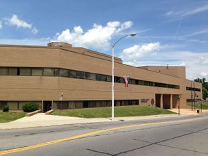
 مبنى محكمة مقاطعة روانوك | |
 الموقع ضمن ولاية Virginia | |
 موقع Virginia ضمن الولايات المتحدة | |
| الإحداثيات: 37°16′N 80°05′W / 37.27°N 80.08°W | |
| البلد | |
| State | |
| تأسست | March 30, 1838 |
| السمِيْ | نهر روانوك |
| Seat | سالم |
| أكبر town | ڤنتون |
| المساحة | |
| • الإجمالي | 251 ميل² (650 كم²) |
| • البر | 251 ميل² (650 كم²) |
| • الماء | 0٫7 ميل² (2 كم²) 0.3%% |
| التعداد (2010) | |
| • الإجمالي | 92٬376 |
| • الكثافة | 363/sq mi (140/km2) |
| منطقة التوقيت | UTC−5 (Eastern) |
| • الصيف (التوقيت الصيفي) | UTC−4 (EDT) |
| Congressional districts | 6th، 9th |
| الموقع الإلكتروني | www |
| [1] | |
مقاطعة روانوك إنگليزية: Roanoke County هي إحدى المقاطعات في ولاية ڤرجينيا في الولايات المتحدة.
التاريخ

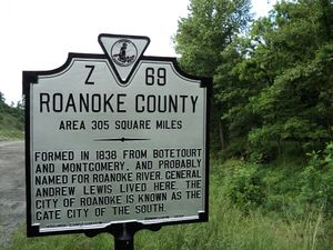
State historical marker لمقاطعة روانوك، ڤرجينيا
الجغرافيا
مقاطعات ومدن مجاورة
- Bedford County, Virginia - East
- Botetourt County, Virginia - Northeast
- Craig County, Virginia - Northwest
- Floyd County, Virginia - Southwest
- Franklin County, Virginia - Southeast
- Montgomery County, Virginia - West
- Roanoke, Virginia - Center (enclave)
- Salem, Virginia - Center (enclave)
مناطق محمية وطنياً
- Blue Ridge Parkway (part)
- Jefferson National Forest (part)
الطرق الرئيسية
السكان
| التعداد | Pop. | ملاحظة | %± |
|---|---|---|---|
| 1840 | 5٬499 | — | |
| 1850 | 8٬477 | 54٫2% | |
| 1860 | 8٬048 | −5٫1% | |
| 1870 | 9٬350 | 16٫2% | |
| 1880 | 13٬105 | 40٫2% | |
| 1890 | 30٬101 | 129٫7% | |
| 1900 | 15٬837 | −47٫4% | |
| 1910 | 19٬623 | 23٫9% | |
| 1920 | 22٬395 | 14٫1% | |
| 1930 | 35٬289 | 57٫6% | |
| 1940 | 42٬897 | 21٫6% | |
| 1950 | 41٬486 | −3٫3% | |
| 1960 | 61٬693 | 48٫7% | |
| 1970 | 67٬339 | 9٫2% | |
| 1980 | 72٬945 | 8٫3% | |
| 1990 | 79٬332 | 8٫8% | |
| 2000 | 85٬778 | 8٫1% | |
| 2010 | 92٬376 | 7٫7% | |
| 2014 (تق.) | 93٬785 | [2] | 1٫5% |
| U.S. Decennial Census[3] 1790-1960[4] 1900-1990[5] 1990-2000[6] 2010-2013[7] | |||
السياسة
| Year | GOP | DEM | Others |
|---|---|---|---|
| 2008 | 60.0% 30,571 | 38.9% 19,812 | 1.2% 592 |
| 2004 | 65.1% 30,596 | 34.2% 16,082 | 0.6% 295 |
| 2000 | 60.1% 25,740 | 37.7% 16,141 | 2.2% 936 |
| 1996 | 52.5% 20,700 | 39.0% 15,387 | 8.4% 3,334 |
| 1992 | 50.3% 20,667 | 35.8% 14,704 | 13.9% 5,709 |
| 1988 | 62.6% 22,011 | 36.8% 12,938 | 0.6% 208 |
| 1984 | 68.6% 23,348 | 31.0% 10,569 | 0.4% 137 |
| 1980 | 55.8% 17,182 | 39.3% 12,114 | 5.0% 1,518 |
| 1976 | 50.4% 13,587 | 48.7% 13,120 | 0.9% 241 |
| 1972 | 77.3% 19,920 | 20.6% 5,318 | 2.1% 540 |
| 1968 | 58.9% 12,439 | 18.5% 3,902 | 22.7% 4,783 |
| 1964 | 54.8% 10,714 | 45.1% 8,808 | 0.1% 14 |
| 1960 | 67.3% 9,109 | 32.4% 4,384 | 0.3% 39 |
انظر أيضاً
الهامش
- ^ Jack, Pp. 6-7
- ^ "Annual Estimates of the Resident Population for Incorporated Places: April 1, 2010 to July 1, 2014". Retrieved June 4, 2015.
- ^ "U.S. Decennial Census". United States Census Bureau. Retrieved January 5, 2014.
- ^ "Historical Census Browser". University of Virginia Library. Retrieved January 5, 2014.
- ^ "Population of Counties by Decennial Census: 1900 to 1990". United States Census Bureau. Retrieved January 5, 2014.
- ^ "Census 2000 PHC-T-4. Ranking Tables for Counties: 1990 and 2000" (PDF). United States Census Bureau. Retrieved January 5, 2014.
- ^ خطأ استشهاد: وسم
<ref>غير صحيح؛ لا نص تم توفيره للمراجع المسماةQF
ببليوگرافيا
- Jack, George S. and Edward Boyle Jacobs, (1912). History of Roanoke County, Stone.
وصلات خارجية

|
Botetourt County | Craig County | 
| |
| Bedford County | Montgomery County | |||
| Franklin County | Floyd County |
الكلمات الدالة:
?
تصنيفات:
- Pages using gadget WikiMiniAtlas
- Short description is different from Wikidata
- مقاطعات Virginia
- Articles containing إنگليزية-language text
- Pages using Lang-xx templates
- Jct template errors
- Pages using US Census population needing update
- Coordinates on Wikidata
- مقاطعة روانوك، ڤرجينيا
- تأسيسات 1838 في الولايات المتحدة
- أماكن مأهولة تأسست في 1838
- منطقة روانوك العمرانية
- مقاطعات ڤرجينيا
