محافظات منغوليا Provinces of Mongolia
(تم التحويل من مقاطعات منغوليا)
| التقسيمات الإدارية في منغوليا |
|---|
| المستوى الأول |
| المستوى الثاني |
| المستوى الثالث |
 |
|---|
|
|
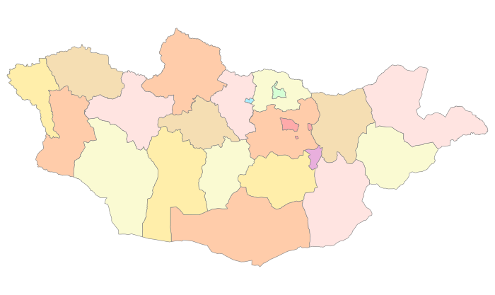
Mongolia is divided into 21 provinces or aimags (منغولية: аймаг) and one provincial municipality.[1] Each aimag is subdivided into several districts.[2][3] The modern provinces have been established since 1921. The capital, Ulaanbaatar, is governed as an independent provincial municipality separate from Töv Province, inside which it is situated.
قائمة المحافظات
| المحافظة (آيمق)[4] |
معنى الاسم | سنة التأسيس |
المساحة (كم²)[5] |
التعداد تعداد 2020[6] |
الكثافة | العاصمة |
|---|---|---|---|---|---|---|
| آرخانگاي: شمال جبال خانگاي | 1931 | 55,313.82 | 94,994 | 1.72 | Tsetserleg[7] | |
| بيان خونگور: المروج اليانعة | 1941 | 115,977.80 | 88,672 | 0.76 | Bayankhongor[8] | |
| بيان-أولگي: المهد اليانع | 1940 | 45,704.89 | 108,530 | 2.37 | Ölgii | |
| بولگان: السمور | 1938 | 48,733.00 | 62,089 | 1.27 | Bulgan | |
| درخان-أول: جبل الحرفيين | 1994 | 3,275.00 | 107,018 | 33 | Darkhan | |
| دورنود: الشرقية | 1941 | 123,597.43 | 82,054 | 0.66 | Choibalsan | |
| دورنوگوڤي: شرق صحراء گوبي | 1931 | 109,472.30 | 71,014 | 0.65 | Sainshand | |
| دوندگوڤي: وسط صحراء گوبي | 1942 | 74,690.32 | 47,104 | 0.63 | Mandalgovi | |
| گوڤي-ألطاي: صحراء ألطاي | 1940 | 141,447.67 | 57,748 | 0.41 | مدينة ألطاي | |
| گوڤي سومبر: قمة گوبي | 1996 | 5,541.80 | 17,928 | 3.23 | Choir | |
| خنتي: جبال خنتي، مهد المنغول | 1930 | 80,325.08 | 77,957 | 0.97 | Öndörkhaan | |
| خوڤد: نهر خوڤد، أي النهر المنثني | 1931 | 76,060.38 | 89,712 | 1.18 | Khovd | |
| خوڤس گول: حوض الماء | 1931 | 100,628.82 | 135,095 | 1.34 | Mörön | |
| أورخون: نهر أورخون ووادي أورخون | 1994 | 844.00 | 107,634 | 128 | Erdenet | |
| أومنو گوڤي: جنوب گوبي | 1931 | 165,380.47 | 69,187 | 0.42 | Dalanzadgad | |
| أوڤور خانگاي: جنوب خانگاي | 1931 | 62,895.33 | 116,732 | 1.86 | أرڤايخير | |
| سلنگى: المفيض | 1934 | 41,152.63 | 110,110 | 2.68 | Sükhbaatar | |
| سوخ باتر: المقاتل بالبلطة | 1943 | 82,287.15 | 63,182 | 0.77 | Baruun-Urt | |
| توڤ: المحافظة الوسطى | 1931 | 74,042.37 | 94,250 | 1.27 | Zuunmod | |
| أوڤس: البحيرة | 1931 | 69,585.39 | 83,223 | 1.20 | Ulaangom | |
| زڤخان: نهر زڤخان، أي "النهر السريع" | 1931 | 82,455.66 | 72,823 | 0.88 | Uliastai | |
(بلدية بمستوى محافظة) |
أولان باتر: المقاتل الأحمر | 1942 | 4,704.40 | 1,539,810 | 327 | أولان باتور |
انظر أيضاً
- ISO 3166-2 codes for Mongolia
- Lists of political and geographic subdivisions by total area
- List of Mongolian provinces by GDP
المراجع
- ^ Buyanjargal (5 April 2017). "Political system". Mongolian National News Agency. Retrieved 10 December 2024.
- ^ Mongolian constitution, article 57
- ^ Montsame News Agency. Mongolia. 2006, Foreign Service office of Montsame News Agency, ISBN 99929-0-627-8, p. 46
- ^ "Provinces of Mongolia". InfoMongolia.com. MER. Archived from the original on 17 December 2014. Retrieved 17 December 2014.
- ^ Mongolia Landuse Annual Report 2007[dead link]
- ^ "2020 Population and Housing Census of Mongolia National Report, table 2.5". National Statistical Office of Mongolia. Archived from the original on 17 August 2021. Retrieved 28 November 2021.
- ^ "Arkhangai Aimag". InfoMongolia.com. 26 May 2014. Archived from the original on 27 October 2011. Retrieved 13 May 2016.
- ^ "Bayankhonghor Aimag". InfoMongolia.com. 23 April 2014. Archived from the original on 16 March 2016. Retrieved 13 May 2016.
وصلات خارجية
This article contains content from Wikimedia licensed under CC BY-SA 4.0. Please comply with the license terms.
تصنيفات:
- Articles with dead external links from June 2016
- Short description is different from Wikidata
- تقسيمات منغوليا
- Articles containing منغولية-language text
- محافظات منغوليا
- Lists of administrative divisions
- Administrative divisions in Asia
- First-level administrative divisions by country
- Mongolia geography-related lists
