تورنگيا Thuringia
| ||||||||||||||||||||||||||||||||||||||||||||||||||||||||
 Map | ||||||||||||||||||||||||||||||||||||||||||||||||||||||||


ثورينگيا أو تورنگن (Thuringia ؛ بالإنگليزية []θəˈrɪndʒiə[]; ألمانية: Thüringen [ˈtyːʁɪŋən] officially the Free State of Thuringia, Freistaat Thüringen [ˈfʁaɪʃtaːt ˈtyːʁɪŋən]) هي إحدى ولايات ألمانيا الستة عشر. كانت قبل الوحدة الألمانية عام 1990 إحدى ولايات جمهورية ألمانيا الديمقراطية. بتعداد 2.1 مليون نسمة، تأتي في المرتبة الثانية عشر بين الولايات من حيث التعداد، وبمساحة 16,171 كيلومتر مربع، تأتي في المرتبة الحادية عشر من حيث المساحة.[5]
Erfurt is the capital and largest city. Other cities include Jena, Gera and Weimar. Thuringia is bordered by Bavaria, Hesse, Lower Saxony, Saxony, and Saxony-Anhalt. It has been known as "the green heart of Germany" (das grüne Herz Deutschlands) from the late 19th century due to its broad, dense forest.[6] Most of Thuringia is in the Saale drainage basin, a left-bank tributary of the Elbe.
The Frankish Duchy of Thuringia was established around 631 AD by King Dagobert I. The modern state was established in 1920 by the Weimar Republic through a merger of the Ernestine duchies, save for Saxe-Coburg. After World War II, Thuringia came under the Soviet occupation zone in Allied-occupied Germany, and its borders were reformed, to become contiguous. Thuringia became part of the German Democratic Republic in 1949, but was dissolved in 1952 during administrative reforms, and divided into the Districts of Erfurt, Suhl and Gera. Thuringia was re-established in 1990 following German reunification, slightly re-drawn, and became one of the new states of the Federal Republic of Germany.
Thuringia is home to the Rennsteig, Germany's best-known hiking trail. Its winter resort of Oberhof makes it a well-equipped winter sports destination – half of Germany's 136 Winter Olympic gold medals had been won by Thuringian athletes as of 2014.[7] Thuringia was favoured by or was the birthplace of three key intellectuals and leaders in the arts: Johann Sebastian Bach, Johann Wolfgang von Goethe, and Friedrich Schiller. The state is home to the University of Jena, the Ilmenau University of Technology, the University of Erfurt, Bauhaus University of Weimar and the Schmalkalden University of Applied Sciences.
أصل الاسم والرموز
 درع أمراء تورنگيا (1265) |
The name Thuringia or Thüringen derives from the Germanic tribe Thuringii, who emerged during the Migration Period. Their origin is largely unknown. An older theory claims that they were successors of the Hermunduri, but later research rejected the idea. Other historians argue that the Thuringians were allies of the Huns, came to central Europe together with them, and lived before in what is Galicia today. Publius Flavius Vegetius Renatus first mentioned the Thuringii around 400; during that period, the Thuringii were famous for their excellent horses.
The Thuringian Realm existed until after 531. The Landgraviate of Thuringia was the largest state in the region, persisting between 1131 and 1247. Afterwards the state known as Thuringia ceased to exist; nevertheless the term commonly described the region between the Harz mountains in the north, the White Elster river in the east, the Franconian Forest in the south and the Werra river in the west. After the Treaty of Leipzig, Thuringia had its own dynasty again, the Ernestine Wettins. Their various lands formed the State of Thuringia, founded in 1920, together with some other small principalities. The Prussian territories around Erfurt, Mühlhausen and Nordhausen joined Thuringia in 1945.
The coat of arms of Thuringia shows the lion of the Ludowingian Landgraves of 12th-century origin. The eight stars around it represent the eight former states which formed Thuringia. The flag of Thuringia is a white-red bicolor, derived from the white and red stripes of the Ludowingian lion. The coat of arms and flag of Hesse are quite similar to the Thuringian ones, since they are also derived from the Ludowingian symbols.
Symbols of Thuringia in popular culture are the Bratwurst and the Forest, because a large amount of the territory is forested.
التاريخ
Named after the Thuringii Germanic tribe who occupied it around AD 300, Thuringia came under Frankish domination in the 6th century.
Thuringia became a landgraviate in 1130 AD. After the extinction of the reigning Ludowingian line of counts and landgraves in 1247 and the War of the Thuringian Succession (1247–1264), the western half became independent under the name of "Hesse", never to become a part of Thuringia again. Most of the remaining Thuringia came under the rule of the Wettin dynasty of the nearby Margraviate of Meissen, the nucleus of the later Electorate and Kingdom of Saxony. With the division of the house of Wettin in 1485, Thuringia went to the senior Ernestine branch of the family, which subsequently subdivided the area into a number of smaller states, according to the Saxon tradition of dividing inheritance amongst male heirs. These were the "Saxon duchies", consisting, among others, of the states of Saxe-Weimar, Saxe-Eisenach, Saxe-Jena, Saxe-Meiningen, Saxe-Altenburg, Saxe-Coburg, and Saxe-Gotha.
Thuringia generally accepted the Protestant Reformation, and Roman Catholicism was suppressed as early as 1520;[بحاجة لمصدر] priests who remained loyal to it were driven away and churches and monasteries were largely destroyed, especially during the German Peasants' War of 1525. In Mühlhausen and elsewhere, the Anabaptists found many adherents. Thomas Müntzer, a leader of some non-peaceful groups of this sect, was active in this city. Within the borders of modern Thuringia the Roman Catholic faith only survived in the Eichsfeld district, which was ruled by the Archbishop of Mainz, and to a small degree in Erfurt and its immediate vicinity.
العصر الحديث المبكر
The modern German black-red-gold tricolour flag's first appearance anywhere in a German-ethnicity sovereign state, within what today comprises Germany, occurred in 1778 as the state flag of the Principality of Reuss-Greiz, a defunct principality within the modern state's borders.

Some reordering of the Thuringian states occurred during the German Mediatisation from 1795 to 1814, and the territory was included within the Napoleonic Confederation of the Rhine organized in 1806. The 1815 Congress of Vienna confirmed these changes and the Thuringian states' inclusion in the German Confederation; the Kingdom of Prussia also acquired some Thuringian territory and administered it within the Province of Saxony. The Thuringian duchies which became part of the German Empire in 1871 during the Prussian-led unification of Germany were Saxe-Weimar-Eisenach, Saxe-Meiningen, Saxe-Altenburg, Saxe-Coburg-Gotha, Schwarzburg-Sondershausen, Schwarzburg-Rudolstadt and the two principalities of Reuss Elder Line and Reuss Younger Line.
ولاية تورنگيا الحرة
In 1920, after World War I, these small states merged into one state, called the State of Thuringia (Land Thüringen); only Saxe-Coburg voted to join Bavaria instead. Weimar became the new capital. The coat of arms of this new state was simpler than those of its predecessors. The Landtag of the newly established state first convened in 1920 in Weimar. Its deputies were elected for three years according to proportional representation, with a minimum voting age of 21. Between 1920 and 1932, under the Weimar Republic, six Landtag elections were held.
Thuringia was one of the states where the Nazi Party first gained real political power during the Weimar Republic. Wilhelm Frick was appointed Minister of the Interior in the state coalition government after the Nazi Party won six deputies to the Thuringian Landtag in the December 1929 election. In this position, he removed from the Thuringian police force anyone he suspected of being a republican and replaced them with men who were favourable towards the Nazis. He also ensured that, whenever an important position came up within Thuringia, a Nazi was given that post. Following the Nazi seizure of power in Berlin, the Landtag was formally abolished as a result of the "Law on the Reconstruction of the Reich" of 30 January 1934, which replaced the German federal system with a unitary state. Thuringia was the location of the Buchenwald concentration camp with multiple subcamps.[8]
After being controlled briefly by the US following the end of the Second World War, from July 1945 the state of Thuringia came under the Soviet occupation zone and was expanded to include parts of Prussian Saxony, such as the areas around Erfurt, Mühlhausen, and Nordhausen. Erfurt became the new capital of Thuringia. Ostheim, an exclave of Landkreis Eisenach, was ceded to Bavaria.
In 1952, the German Democratic Republic dissolved its states, and created districts (Bezirke) instead. The three districts that shared the former territory of Thuringia were Erfurt, Gera and Suhl. Altenburg Kreis was part of Leipzig Bezirk.
The present Free State of Thuringia was recreated with slightly altered borders during German reunification in 1990.
الجغرافيا
ثورينگيا تقع في الوسط الجغرافي لألمانيا وتتألف من حوض تورنگن وغابه تورنغن، تمتد الولاية من جهة الغرب حتى نهر فيرا من جهة الجنوب الشرقي حتى حتى نهر إلستر الابيض مرورا بنهر زاله. وفي جنوبها الشرقي تقع سلسلة جبال الرون وتحدها من الجنوب الغابة الفرانكونية، لها حدود مع خمس ولايات المانية اخرى: بايرن، ساكسونيا ،ساكسن أنهالت ،براندنبورغ و هيسين.
التقسيم الاداري وأهم المدن
ارفورت هي عاصمة تورنگن وأكبر مدنها حيث يبلغ عدد سكانها 196.500 نسمة. الولاية مقسمة إلى 17 دائرة قروية و6 دوائر حضرية. غيرا, يينا و فايمر هم أهم المدن بعد العاصمة.

بالاضافة إلى ذلك هناك ست مناطق حضرية:
البلدات
| البلدات في ثورينگيا | |||||
| الموقع | البلدة | السكان | المنطقة | ||
| 31 ديسمبر 1970 | 31 ديسمبر 2000 | 30 June 2005 | |||
| 1. | إرفورت | 192.679 | 200.564 | 202.590 | مدينة مستقلة |
| 2. | گـِرا | 106.841 | 112.835 | 104.737 | مدينة مستقلة |
| 3. | ينا | 85.169 | 99.893 | 102.201 | مدينة مستقلة |
| 4. | ڤايمار | 63.985 | 62.425 | 64.361 | مدينة مستقلة |
| 5. | گوثا | 57.256 | 48.376 | 47.045 | Gotha |
| 6. | أيزناخ | 50.059 | 44.442 | 43.858 | مدينة مستقلة |
| 7. | نوردهاوزن | 42.018 | 45.633 | 43.781 | Nordhausen |
| 8. | سول | 28.177 | 48.025 | 43.202 | مدينة مستقلة |
| 9. | ألتنبورگ | 47.497 | 41.290 | 38.203 | Altenburger Land |
| 10. | Mühlhausen | 46.135 | 38.695 | 37.480 | Unstrut-Hainich-Kreis |
| 11. | سالفلد | 31.048 | 29.511 | 28.148 | Saalfeld-Rudolstadt |
| 12. | Ilmenau | 19.634 | 27.176 | 26.713 | Ilm-Kreis |
| 13. | آرنشتات | 27.368 | 27.220 | 25.828 | إلم-كرايس |
| 14. | Rudolstadt | 30.087 | 27.528 | 25.584 | Saalfeld-Rudolstadt |
| 15. | Apolda | 29.754 | 25.899 | 24.684 | Weimarer Land |
| 16. | Greiz | 39.424 | 26.177 | 24.007 | Greiz |
| 17. | Sonneberg | 29.811 | 24.837 | 23.928 | Sonneberg |
| 18. | Sondershausen | 22.195 | 23.088 | 21.718 | Kyffhäuserkreis |
| 19. | Meiningen | 24.876 | 22.240 | 21.642 | Schmalkalden-Meiningen |
| 20. | Sömmerda | 15.959 | 21.977 | 20.885 | Sömmerda |
| 21. | Leinefelde-Worbis (formed on 16 March 2004) |
4.315 (LF) 3.401 (WO) |
15.056 (LF) 5.497 (WO) |
20.816 | Eichsfeld |
| 22. | Bad Langensalza | 16.813 | 19.917 | 18.760 | Unstrut-Hainich-Kreis |
| 23. | Schmalkalden | 14.527 | 18.551 | 17.893 | Schmalkalden-Meiningen |
| 24. | Zeulenroda-Triebes (formed on 1 مارس 2006) |
13.549 (ZR) 4.790 (TR) |
14.600 (ZR) 4.230 (TR) |
17.702 | Greiz |
| 25. | Heiligenstadt | 12.464 | 17.291 | 17.175 | Eichsfeld |
| 26. | Bad Salzungen | 11.466 | 17.086 | 16.551 | Wartburgkreis |
| 27. | Pößneck | 19.547 | 14.341 | 13.592 | Saale-Orla-Kreis |
| 28. | Schmölln | 13.968 | 13.193 | 12.693 | Altenburger Land |
| 29. | Zella-Mehlis (formed on 1 April 1919) |
17.136 | 13.036 | 12.355 | Schmalkalden-Meiningen |
| 30. | Hildburghausen | 10.652 | 12.466 | 12.351 | Hildburghausen |
| 31. | Eisenberg | 13.859 | 11.764 | 11.489 | Saale-Holzland-Kreis |
| 32. | ڤالترشاوسن | 14.219 | 11.725 | 11.307 | گوثا |
السياسة
قائمة الرؤساء-الوزراء لتورنگن
- 1920 - 1921: Arnold Paulssen (DDP)
- 1921 - 1923: August Frölich (SPD)
- 1924 - 1928: Richard Leutheußer (DVP)
- 1928 - 1929: Karl Riedel (DVP)
- 1929 : Arnold Paulssen (DDP)
- 1930 - 1932: Erwin Baum (Landbund)
- 1932 - 1933: Fritz Sauckel (NSDAP)
- 1933 - 1945: Willy Marschler (NSDAP)
- 1945: Hermann Brill (SPD)
- 1945 - 1947: Rudolf Paul (no party, then LDPD)
- 1947 - 1952: Werner Eggerath (SED)
- 1990 - 1992: Josef Duchac (CDU)
- 1992 - 2003: Bernhard Vogel (CDU)
- since 2003: Dieter Althaus (CDU)
انتخابات الولاية في 13 يونيو, 2004
| Party | Party List votes | Vote percentage | Total Seats | Seat percentage |
|---|---|---|---|---|
| Christian Democratic Union (CDU) | 434,088 | 43.0% | 45 | 51.1% |
| Party of Democratic Socialism (PDS) | 263,717 | 26.1% | 28 | 31.8% |
| Social Democratic Party (SPD) | 146,297 | 14.5% | 15 | 17.0% |
| Alliance '90/The Greens | 45,649 | 4.5% | 0 | 0.0% |
| Free Democratic Party (FDP) | 36,483 | 3.6% | 0 | 0.0% |
| Free Voters in Thuringia | 26,302 | 2.6% | 0 | 0.0% |
| The Republicans | 19,797 | 2.0% | 0 | 0.0% |
| National Democratic Party (NPD) | 15,695 | 1.6% | 0 | 0.0% |
| كل ما عداهم | 22,549 | 2.2% | 0 | 0.0% |
| إجماليات | 1,010,578 | 100.0% | 88 | 100.0% |

المواصلات
- Autobahn: A4, A9, A38, A44, A71, A73
- Airports: Altenburg-Nobitz Airport, Erfurt Airport
الاقتصاد


تملك تورنگن مساحات زراعية شاسعة. تعاني الولاية كباقي مثيلاتها بشرق ألمانيا من نسبة بطالة عالية ومن هروب الأيدي العاملة الشابة. تقوم الحكومة الألمانية منذ إعادة توحيد ألمانيا بالإستثمار في اقتصاد الولاية و خاصة في تنمية البنية التحتية.
Thuringia's economy is marked by the economic transition that happened after the German reunification and led to the closure of most of the factories within the Land. The unemployment rate reached a peak in 2005. Since that year, the economy has seen an upturn and the general economic situation has improved.
الزراعة والتحريج
Agriculture and forestry have declined in importance over the decades. Nevertheless, they are more important than in most other areas of Germany, especially within rural regions. 54% of Thuringia's territory is in agricultural use. The fertile basins such as the large Thuringian Basin or the smaller Goldene Aue, Orlasenke and Osterland are in intensive use for growing cereals, vegetables, fruits and energy crops. Important products are apples, strawberries, cherries and plums in the fruit sector, cabbage, potatoes, cauliflower, tomatoes (grown in greenhouses), onions, cucumbers and asparagus in the vegetable sector, as well as maize, rapeseed, wheat, barley and sugar beets in the crop sector.
Meat production and processing is also an important activity, with pigs, cattle, chickens and turkeys in focus. Furthermore, there are many milk and cheese producers, as well as laying hens. Trout and carp are traditionally bred in aquaculture in many villages.
Most agricultural enterprises are large cooperatives, founded as Landwirtschaftliche Produktionsgenossenschaft during the GDR period, and meat producers are part of multinational companies. Traditional private peasant agriculture is an exception, as is organic farming.
Thuringia's only wine-growing district is around Bad Sulza north of Weimar and Jena along the Ilm and Saale valley. Its production is marketed as Saale-Unstrut wines.
Forestry plays an important role in Thuringia because 32% of the Thuringian territory is forested. The most common trees are spruce, pine and beech. There are many wood and pulp-paper factories near the forested areas.
الصناعة والتعدين
Like most other regions of central and southern Germany, Thuringia has a significant industrial sector reaching back to the mid-19th-century industrialisation. The economic transition after the German reunification in 1990 led to the closure of most large-scale factories and companies, leaving small and medium-sized ones to dominate the manufacturing sector. Well-known industrial centres are Jena (a world centre for optical instruments with companies like Carl Zeiss, Schott and Jenoptik) and Eisenach, where BMW started its car production in the 1920s and an Opel factory is based today. The most important industrial branches today are engineering and metalworking, vehicle production and food industries. Especially the small and mid-sized towns in central and southwestern Thuringia (e.g. Arnstadt, Schmalkalden and Ohrdruf) are highly industrialised, whereas there are fewer industrial companies in the northern and eastern parts of the Land. Traditional industries like production of glass, porcelain and toys collapsed during the economic crises between 1930 and 1990.
Mining was important in Thuringia since the later Middle Ages, especially within the mining towns of the Thuringian Forest such as Schmalkalden, Suhl and Ilmenau. Following the industrial revolution, the old iron, copper and silver mines declined because the competition from imported metal was too strong. On the other hand, the late 19th century brought new types of mines to Thuringia: the lignite surface mining around Meuselwitz near Altenburg in the east of the Land started in the 1870s, and two potash mining districts were established around 1900. These are the Südharzrevier in the north of the state, between Bischofferode in the west and Roßleben in the east with Sondershausen at its centre, and the Werrarevier on the Hessian border around Vacha and Bad Salzungen in the west. Together, they accounted for a significant part of the world's potash production in the mid-20th century. After the reunification, the Südharzrevier was abandoned, whereas K+S took over the mines in the Werrarevier. Between 1950 and 1990, uranium mining was also important to cover the Soviet Union's need for this metal. The centre was Ronneburg near Gera in eastern Thuringia and the operating company Wismut was under direct Soviet control.
المؤشرات الاقتصادية العامة
The GDP of Thuringia is below the national average, in line with the other former East German Lands. Until 2004, Thuringia was one of the weakest regions within the European Union. The accession of several new countries, the crisis in southern Europe and the sustained economic growth in Germany since 2005 has brought the Thuringian GDP close to the EU average since then. The high economic subsidies granted by the federal government and the EU after 1990 are being reduced gradually and will end around 2020.
The unemployment rate reached its peak of 17.1% in 2005. Since then, it has decreased to 5.3% in 2019, which is only slightly above the national average. The decrease is caused on the one hand by the emergence of new jobs and on the other by a marked decrease in the working-age population, caused by emigration and low birth rates for decades. The wages in Thuringia are low compared to rich bordering Lands like Hesse and Bavaria. Therefore, many Thuringians are working in other German Lands and even in Austria and Switzerland as weekly commuters. Nevertheless, the demographic transition in Thuringia leads to a lack of workers in some sectors. External immigration into Thuringia has been encouraged by the government since about 2010 to counter this problem.
The economic progress is quite different between the regions of Thuringia. The big cities along the A4 motorway such as Erfurt, Jena and Eisenach and their surroundings are booming, whereas nearly all the rural regions, especially in the north and east, have little economic impetus and employment, which is a big issue in regional planning. Young people in these areas often have to commute long distances, and many emigrate soon after finishing school.
The unemployment rate stood at 5.9% in 2023 and was higher than the German average.[10][11]
| Year[12][10] | 2000 | 2001 | 2002 | 2003 | 2004 | 2005 | 2006 | 2007 | 2008 | 2009 | 2010 | 2011 | 2012 | 2013 | 2014 | 2015 | 2016 | 2017 | 2018 | 2019 | 2020 | 2021 | 2022 | 2023 |
|---|---|---|---|---|---|---|---|---|---|---|---|---|---|---|---|---|---|---|---|---|---|---|---|---|
| Unemployment rate in % | 15.4 | 15.3 | 15.9 | 16.7 | 16.7 | 17.1 | 15.6 | 13.1 | 11.2 | 11.4 | 9.8 | 8.8 | 8.5 | 8.2 | 7.8 | 7.4 | 6.7 | 6.1 | 5.5 | 5.3 | 6.0 | 5.6 | 5.3 | 5.9 |
السياحة
تقع قلعة ڤارتبورغ قرب مدينة أيزناخ، وهي مكان اقامة مارتن لوثر خلال الفترة التي ترجم فيها الانجيل إلى الالمانية عام 1522. مدينة ڤايمار كانت مركز النشاط الفكري الالماني والاوروبي في نهاية القرن الثامن عشر التي عاش فيها الشاعر الالماني الشهير گوته وفريدريش شيلّر.
Tourism is an important branch of the economy. Thuringia has a number of well known destinations: Wartburg castle (UNESCO World Heritage Site), Classical Weimar (UNESCO World Heritage Site), Bauhaus Weimar (UNESCO World Heritage Site), Thuringian Forest, Oberhof or Rennsteig (ridge walk). City tourism with the centers of Erfurt, Weimar, Jena, Eisenach and Mühlhausen is experiencing dynamic growth. A total of around 9.2 million overnight stays were booked in 2016, compared to 8.3 million ten years earlier. Around 6% of the bookings were made by foreign guests.[13]

Erfurt skyline
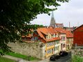
Oldtown of Mühlhausen


البنية التحتية
النقل


As Germany's most central state, Thuringia is an important hub of transit traffic. The transportation infrastructure was in very poor condition after the GDR period. Since 1990, many billions of Euros have been invested to improve the condition of roads and railways within Thuringia.
During the 1930s, the first two motorways were built across the Land, the A4 motorway as an important east–west connection in central Germany and the main link between Berlin and south-west Germany, and the A9 motorway as the main north–south route in eastern Germany, connecting Berlin with Munich. The A4 runs from Frankfurt in Hesse via Eisenach, Gotha, Erfurt, Weimar, Jena and Gera to Dresden in Saxony, connecting Thuringia's most important cities. At Hermsdorf junction it is connected with the A9. Both highways were widened from four to six lanes (three each way) after 1990, including some extensive re-routing in the Eisenach and Jena areas. Furthermore, three new motorways were built during the 1990s and 2000s. The A71 crosses the Land in southwest–northeast direction, connecting Würzburg in Bavaria via Meiningen, Suhl, Ilmenau, Arnstadt, Erfurt and Sömmerda with Sangerhausen and Halle in Saxony-Anhalt. The crossing of the Thuringian Forest by the A71 has been one of Germany's most expensive motorway segments with various tunnels (including Germany's longest road tunnel, the Rennsteig Tunnel) and large bridges. The A73 starts at the A71 south of Erfurt in Suhl and runs south towards Nuremberg in Bavaria. The A38 is another west–east connection in the north of Thuringia running from Göttingen in Lower Saxony via Heiligenstadt and Nordhausen to Leipzig in Saxony. Furthermore, there is a dense network of federal highways complementing the motorway network. The upgrading of federal highways is prioritised in the federal trunk road programme 2015 (Bundesverkehrswegeplan 2015). Envisaged projects include upgrades of the B247 from Gotha to Leinefelde to improve Mühlhausen's connection to the national road network, the B19 from Eisenach to Meiningen to improve access to Bad Salzungen and Schmalkalden, and the B88 and B281 for strengthening the Saalfeld/Rudolstadt region.
The first railways in Thuringia had been built in the 1840s and the network of main lines was finished around 1880. By 1920, many branch lines had been built, giving Thuringia one of the densest rail networks in the world before World War II with about 2,500 km of track. Between 1950 and 2000 most of the branch lines were abandoned, reducing Thuringia's network by half compared to 1940. On the other hand, most of the main lines were refurbished after 1990, resulting in improved speed of travel. The most important railway lines at present are the Thuringian Railway, connecting Halle and Leipzig via Weimar, Erfurt, Gotha and Eisenach with Frankfurt and Kassel and the Saal Railway from Halle/Leipzig via Jena and Saalfeld to Nuremberg. The former has an hourly ICE/IC service from Dresden to Frankfurt while the latter is served hourly by ICE trains from Berlin to Munich. In 2017, a new high speed line will be opened, diverting long-distance services from these mid-19th century lines. Both ICE routes will then use the Erfurt–Leipzig/Halle high-speed railway, and the Berlin-Munich route will continue via the Nuremberg–Erfurt high-speed railway. Only the segment west of Erfurt of the Frankfurt-Dresden line will continue to be used by ICE trains after 2017, with an increased line speed of 200 km/h (currently 160 km/h). Erfurt's central station, which was completely rebuilt for this purpose in the 2000s (decade), will be the new connection between both ICE lines. The most important regional railway lines in Thuringia are the Neudietendorf–Ritschenhausen railway from Erfurt to Würzburg and Meiningen, the Weimar–Gera railway from Erfurt to Chemnitz, the Sangerhausen–Erfurt railway from Erfurt to Magdeburg, the Gotha–Leinefelde railway from Erfurt to Göttingen, the Halle–Kassel railway from Halle via Nordhausen to Kassel and the Leipzig–Hof railway from Leipzig via Altenburg to Zwickau and Hof. Most regional and local lines have hourly service, but some run only every other hour.
A few small airports are in Thuringia. In public transport is Erfurt–Weimar Airport, used for charter flights to the Mediterranean and other holiday destinations. In private flights, Leipzig–Altenburg Airport is a further key airport.
International hub airports are Frankfurt Airport, Berlin Brandenburg Airport and Munich Airport in adjacent states.
Thuringia is the only state without barge or ship waterways; its rivers are too small to be navigable to them.
الطاقة والإمداد بالمياه
The traditional energy supply of Thuringia is lignite, mined in the bordering Leipzig region. Since 2000, the importance of environmentally unfriendly lignite combustion has declined in favour of renewable energies, which reached an amount of 40% (in 2013), and more clean gas combustion, often carried out as cogeneration in the municipal power stations. The most important forms of renewable energies are wind power and biomass, followed by solar energy and hydroelectricity. Furthermore, Thuringia hosts two big pumped storage stations: the Goldisthal Pumped Storage Station and the Hohenwarte Dam.
The water supply is granted by the big dams, like the Leibis-Lichte Dam, within the Thuringian Forest and the Thuringian Highland, making a drinking water exporter of Thuringia.
الصحة
Health care provision in Thuringia improved after 1990, as did the level of general health. Life expectancy rose, nevertheless it is still a bit lower than the German average. This is caused by a relatively unhealthy lifestyle of the Thuringians, especially in high consumption of grains, industrial seed oils, refined carbohydrates and alcohol, which led to significant higher rates of obesity compared to the German average.
Health care in Thuringia is currently undergoing a concentration process. Many smaller hospitals in the rural towns are closing, whereas the bigger ones in centres like Jena and Erfurt get enlarged. Overall, there is an oversupply of hospital beds, caused by rationalisation processes in the German health care system, so that many smaller hospitals generate losses. On the other hand, there is a lack of family doctors, especially in rural regions with increased need of health care provision because of overageing.
التعليم
In Germany, the educational system is part of the sovereignty of the Länder; therefore each Land has its own school and college system.
نظام المدارس
The Thuringian school system was developed after the reunification in 1990, combining some elements of the former GDR school system with the Bavarian school system. Most German school rankings attest that Thuringia has one of the most successful education systems in Germany, resulting in high-quality outcomes.
Early-years education is quite common in Thuringia. Since the 1950s, nearly all children have been using the service, whereas early-years education is less developed in western Germany. Its inventor Friedrich Fröbel lived in Thuringia and founded the world's first Kindergartens there in the 19th century. The Thuringian primary school takes four years and most primary schools are all-day schools offering optional extracurricular activities in the afternoon. At the age of ten, pupils are separated according to aptitude and proceed to either the Gymnasium or the Regelschule. The former leads to the Abitur exam after a further eight years and prepares for higher education, while the latter has a more vocational focus and finishes with exams after five or six years, comparable to the Hauptschule and Realschule found elsewhere in Germany.
Thuringia is home to a K-12 international school in the city of Weimar, Thuringia International School (ThIS). The school was established in the year 2000 and is accredited by the Council of International Schools and authorised to offer the International Baccalaureate PYP, MYP and DP. Students who graduate from the school are able to gain admission to colleges and universities around the world.
الجامعات

The German higher education system comprises two forms of academic institutions: universities and polytechnics (Fachhochschule). The University of Jena is the biggest amongst Thuringia's four universities and offers nearly every discipline. It was founded in 1558, and today has 21,000 students. The second-largest is the Technische Universität Ilmenau with 7,000 students, founded in 1894, which offers many technical disciplines such as engineering and mathematics. The University of Erfurt, founded in 1392, has 5,000 students today and an emphasis on humanities and teacher training. The Bauhaus University Weimar with 4,000 students is Thuringia's smallest university, specialising in creative subjects such as architecture and arts. It was founded in 1860 and came to prominence as Germany's leading art school during the inter-war period, the Bauhaus.
The polytechnics of Thuringia are based in Erfurt (4,500 students), Jena (5,000 students), Nordhausen (2,500 students) and Schmalkalden (3,000 students). In addition, there is a civil service college in Gotha with 500 students, the College of Music "Franz Liszt" in Weimar (800 students) as well as two private colleges, the Adam-Ries-Fachhochschule in Erfurt (500 students) and the SRH College for nursing and allied medical subjects (SRH Fachhochschule für Gesundheit Gera) in Gera (500 students). The most recent institution of higher education in Thuringia is the Duale Hochschule Gera-Eisenach (1400 students), a cooperative state college founded in 2016 through a merger of the colleges (Berufsakademie) في گـِرا وآيزناخ.
البحث العلمي
Thuringia's leading research centre is Jena, followed by Ilmenau. Both focus on technology, in particular life sciences and optics at Jena and information technology at Ilmenau. Erfurt is a centre of Germany's horticultural research, whereas Weimar and Gotha with their various archives and libraries are centres of historic and cultural research. Most of the research in Thuringia is publicly funded basic research due to the lack of large companies able to invest significant amounts in applied research, with the notable exception of the optics sector at Jena.
شخصيات
- Georg Böhm (1661–1733), composer and organist of the Baroque period, born in Hohenkirchen
- Johann Sebastian Bach (1685–1750), composer and musician of the Baroque period, born in Eisenach
- Franz Liszt (1811–1886), Hungarian composer, virtuoso pianist, conductor, teacher and Franciscan tertiary, lived in Weimar
- Richard Wagner (1813–1883), composer, theatre director, polemicist, and conductor, sojourns in Weimar and Eisenach
- Richard Strauss (1864–1949), composer of the late Romantic and early modern eras, director of the Weimar Court Orchestra (Hofkapellmeister)
- Martin Luther (1483–1546), friar (Observant Augustinian), Catholic priest, professor of theology and seminal figure of the 16th-century movement in Christianity known later as the Protestant Reformation, educated in Eisenach, translation of the New Testament from Greek into German at Wartburg castle
- Johann Wolfgang von Goethe (1749–1832), writer and statesman, went to live in Weimar
- Friedrich von Schiller (1759–1805), poet, philosopher, historian, and playwright; professor of history at the University of Jena before relocating to Weimar
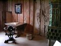
Chamber of Martin Luther at Wartburg castle
- Meister Eckhart O.P. (ح. 1260), theologian, philosopher and mystic, born near Gotha
- Lucas Cranach the Elder (1472–1553), Renaissance painter and printmaker in woodcut and engraving, lived his last years in Weimar
- Johann Gottfried von Herder (1744–1803), philosopher, theologian, poet, and literary critic, introduces the Zeitgeist in Kritische Wälder (1769), served as General Superintendent in Weimar
- Christoph Wilhelm Hufeland (1762–1836), physician, most eminent practical physician of his time in Germany, born in Langensalza
- Napoléon Bonaparte (1769–1821), French military and political leader, twin battle of Jena-Auerstedt, 14 October 1806, met Johann Wolfgang von Goethe at the governor's palace in Erfurt in the presence of Talleyrand, 2 October 1808 ("Vous êtes un homme. Quel âge avez-vous ? – Soixante ans. – Vous êtes bien conservé. Vous avez écrit des tragédies ?") ("Voilà un homme")
- Georg Wilhelm Friedrich Hegel (1770–1831), philosopher, author of the Phenomenology of Spirit, extraordinary Professor at University of Jena
- Carl Zeiss (1816–1888), maker of optical instruments commonly known for the company he founded, Carl Zeiss Jena, born in Weimar
- Karl Marx (1818–1883), philosopher, economist, social scientist, sociologist, historian, journalist, and revolutionary socialist, PhD awarded by University of Jena
- August Schleicher (1821–1868), linguist, he attempted to reconstruct the Proto-Indo-European language
- Johannes Brahms (1833–1897), composer and pianist, frequent sojourns at Meiningen
- Ernst Haeckel (1834–1919), biologist, naturalist, philosopher, physician, professor, and artist, discovered, described, and named thousands of new species, mapped a genealogical tree relating all life forms, coined many terms in biology, including anthropogeny, ecology, phylum, phylogeny, and stem cell, professor at University of Jena
- Ernst Abbe (1840–1905), physicist, optical scientist, entrepreneur, and social reformer, laid the foundations of modern optics, co-owner of Carl Zeiss Jena, born in Eisenach
- Friedrich Wilhelm Nietzsche (1844–1900), philologist, philosopher, cultural critic, poet and composer, lived his last years in Weimar
- Gottlob Frege (1848–1925), mathematician, logician, and philosopher, professor at University of Jena
- Otto Schott (1851–1935), chemist, glass technologist, and the inventor of borosilicate glass, founder of Jenaer Glaswerk Schott & Genossen
- Rudolf Steiner (1861–1925), Austrian philosopher, social reformer, architect, and esotericist, worked to establish various practical endeavors, including Waldorf education, biodynamic agriculture, and anthroposophical medicine, invited to work as an editor at the Goethe Matenadaran in Weimar
- Henry van de Velde (1863–1957), Belgian painter, architect and interior designer, established the Weimar Saxon-Grand Ducal Art School, the predecessor of the Bauhaus
- Max Weber (1864–1920), sociologist, philosopher, and political economist, often cited as among the three founding creators of sociology, born in Erfurt
- Richard Strauss (1864–1949), leading German composer of the late Romantic and early modern eras, director of the Weimar Court Orchestra (Hofkapellmeister) 1889–94
- Vassily Kandinsky (1866–1944), influential Russian painter and art theorist, credited with painting the first purely abstract works, Bauhaus master, Weimar
- Lyonel Feininger (1871–1956), German-American painter and leading exponent of Expressionism, also worked as a caricaturist and comic strip artist, Bauhaus master, Weimar
- Léon Blum (1872–1950), French politician, three times Prime Minister of France, imprisoned in Buchenwald
- Paul Klee (1879–1940), Swiss German painter; his highly individual style was influenced by movements in art that included expressionism, cubism, and surrealism, Bauhaus master, Weimar
- Walter Gropius (1883–1969), architect, widely regarded as one of the pioneering masters of modern architecture, founder of the Bauhaus, Weimar
- Ludwig Mies van der Rohe (1886–1969), German-American architect, widely regarded as one of the pioneering masters of modern architecture, joined the Bauhaus, Weimar
- Jean Arp (1886–1966), German-French, or Alsatian, sculptor, painter, poet and abstract artist, studied at the Weimar Saxon-Grand Ducal Art School, the predecessor of the Bauhaus
- Otto Dix (1891–1969), painter and printmaker, noted for his ruthless and harshly realistic depictions of Weimar society and the brutality of war, born in Untermhaus (today Gera)
- Cuno Hoffmeister (1892–1968), German astronomer, observer and discoverer of variable stars, comets and minor planets, founder of Sonneberg Observatory.
- Werner Braune (1909–1951), Nazi SS officer, executed for war crimes
- Uziel Gal (1923–2002), Israeli gun designer, best remembered as the designer and namesake of the Uzi submachine gun, born in Weimar
- Jorge Semprún (1923–2011), Spanish writer and politician, deported to Buchenwald, realization of "Mère blafarde, tendre sœur" for the Kunstfest art festival, Weimar, summer 1995
- Herbert Kroemer (1928-2024), German-American physicist, co-laureate of the Nobel Prize in Physics 2000
- Marcel Kittel (born 1988 in Arnstadt), professional cyclist
- Michael Roth (1936–2019), engineer


.jpg&filetimestamp=20070721031538&)


ملاحظات
المصادر
- ^ "Fläche und Bevölkerung". Statistische Ämter des Bundes und der Länder (in الألمانية). Retrieved 2025-06-18.
- ^ "Upps".
- ^ "Gross domestic product, gross value added in the states of the Federal Republic of Germany 1991 to 2024 (Series 1 Volume 1)". Statistische Ämter des Bundes und der Länder (in الألمانية). 2025.
- ^ "Subnational HDI". hdi.globaldatalab.org (in الإنجليزية). Retrieved 17 June 2025.
- ^ "Thüringer Landesamt für Statistik". statistik.thueringen.de. Retrieved 21 July 2021.
- ^ Verein Fur Naturkunde, Kassel (30 July 2009). A. Trinius (1898). Retrieved 21 February 2014.
- ^ "Thüringen - Training Grounds for Olympic Athletes". Archived from the original on 22 February 2008.
- ^ "Buchenwald war überall". aussenlager-buchenwald.de (in الألمانية). Retrieved 27 June 2024.
- ^ "Zukunftsatlas: Leipzig ist dynamischste Region Deutschlands". www.lvz.de. 5 July 2019.
- ^ أ ب "Arbeitslosenquote* in Thüringen von 2001 bis 2019". Statista (in الألمانية). Retrieved 2 February 2020.
- ^ "Arbeitslosenquote nach Bundesländern 2023". Statista (in الألمانية). Retrieved 2024-02-11.
- ^ "Federal Statistical Office Germany - GENESIS-Online". www-genesis.destatis.de (in الإنجليزية). 13 November 2018. Archived from the original on 13 November 2018. Retrieved 13 November 2018.
- ^ "Thüringer Landesamt für Statistik".
وصلات خارجية
- موقع تورنگن الرسمي: [1]
- Official government web site
- Tourist website for Thuringia (بالألمانية)
- Tourist website with many pictures of thuringian landscapes (بالألمانية)
- Alternative Tourist website for Thuringia (بالألمانية) (إنگليزية)
- تورنجيا at the Open Directory Project
- Thuringian flags at [2] and [3]
- Searchengine for Thuringia with videos (بالألمانية)
| الولايات |  | |
|---|---|---|
| المدن الولايات | ||
| ولايات سابقة | ||
قالب:Germany districts Thuringia
| الولايات | .svg&filetimestamp=20080207024458&) | ||||||
|---|---|---|---|---|---|---|---|
| المدن الولايات | |||||||
| حتى 1920 | |||||||
| ولايات غير رسمية | |||||||
- CS1 الألمانية-language sources (de)
- Short description is different from Wikidata
- Articles with hatnote templates targeting a nonexistent page
- Missing redirects
- Articles containing ألمانية-language text
- Pages using gadget WikiMiniAtlas
- Articles with unsourced statements from November 2014
- Articles containing فرنسية-language text
- تورنگيا
- ولايات ألمانيا
- ولايات جمهورية ڤايمار
- أقاليم التصنيف الثاني في الاتحاد الأوروپي
- ولايات وأقاليم تأسست في 1920
- انحلالات 1952 في ألمانيا الشرقية
- ولايات وأقاليم تأسست في 1990
- جمهوريات سابقة
- صفحات مع الخرائط