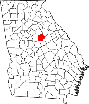
مقاطعة پتنم، جورجيا
Putnam County | |
|---|---|
 Putnam County courthouse in Eatonton | |
 الموقع ضمن ولاية Georgia | |
 موقع Georgia ضمن الولايات المتحدة | |
| الإحداثيات: 33°19′N 83°22′W / 33.32°N 83.37°W | |
| البلد | |
| State | |
| تأسست | December 10, 1807 |
| السمِيْ | Israel Putnam |
| Seat | Eatonton |
| أكبر مدينة | Eatonton |
| المساحة | |
| • الإجمالي | 361 ميل² (930 كم²) |
| • البر | 345 ميل² (890 كم²) |
| • الماء | 16 ميل² (40 كم²) 4.4%% |
| التعداد (2010) | |
| • الإجمالي | 21٬218 |
| • الكثافة | 62/sq mi (24/km2) |
| منطقة التوقيت | UTC−5 (Eastern) |
| • الصيف (التوقيت الصيفي) | UTC−4 (EDT) |
| Congressional district | 10th |
| الموقع الإلكتروني | www |
مقاطعة پتنم إنگليزية: Putnam County هي إحدى المقاطعات في ولاية جورجيا في الولايات المتحدة الأمريكية.
الجغرافيا
المقاطعات المجاورة
- Morgan County (north)
- Greene County (northeast)
- Hancock County (east)
- Baldwin County (southeast)
- Jones County (southwest)
- Jasper County (west)
National protected area
- Oconee National Forest (part)
السكان
| التعداد تاريخياً | |||
|---|---|---|---|
| الإحصاء | التعداد | %± | |
| 1810 | 10٬029 | ||
| 1820 | 15٬475 | 54.3% | |
| 1830 | 13٬261 | -14.3% | |
| 1840 | 10٬260 | -22.6% | |
| 1850 | 10٬794 | 5.2% | |
| 1860 | 10٬125 | -6.2% | |
| 1870 | 10٬461 | 3.3% | |
| 1880 | 14٬539 | 39.0% | |
| 1890 | 14٬842 | 2.1% | |
| 1900 | 13٬436 | -9.5% | |
| 1910 | 13٬876 | 3.3% | |
| 1920 | 15٬151 | 9.2% | |
| 1930 | 8٬367 | -44.8% | |
| 1940 | 8٬514 | 1.8% | |
| 1950 | 7٬731 | -9.2% | |
| 1960 | 7٬798 | 0.9% | |
| 1970 | 8٬394 | 7.6% | |
| 1980 | 10٬295 | 22.6% | |
| 1990 | 14٬137 | 37.3% | |
| 2000 | 18٬812 | 33.1% | |
| 2010 | 21٬218 | 12.8% | |
| تقديري 2013 | 21٬371 | 13.6% | |
Communities
Education
The Putnam County Charter School System serves the community.
See also
- National Register of Historic Places listings in Putnam County, Georgia
- Tama-Re
- Rock Eagle Effigy Mound
- Rock Hawk Effigy Mound
References
- ^ "U.S. Decennial Census". United States Census Bureau. Retrieved June 25, 2014.
- ^ "Historical Census Browser". University of Virginia Library. Retrieved June 25, 2014.
- ^ "Population of Counties by Decennial Census: 1900 to 1990". United States Census Bureau. Retrieved June 25, 2014.
- ^ "Census 2000 PHC-T-4. Ranking Tables for Counties: 1990 and 2000" (PDF). United States Census Bureau. Retrieved June 25, 2014.
- ^ خطأ استشهاد: وسم
<ref>غير صحيح؛ لا نص تم توفيره للمراجع المسماةQF
وصلات خارجية

|
Greene County | Morgan County | 
| |
| Hancock County | Jasper County | |||
| Baldwin County | Jones County |
الكلمات الدالة:
?
تصنيفات:
- Pages using gadget WikiMiniAtlas
- Short description is different from Wikidata
- Georgia (U.S. state) counties
- Articles containing إنگليزية-language text
- Pages using Lang-xx templates
- Pages with empty portal template
- Coordinates on Wikidata
- Atlanta metropolitan area counties
- مقاطعات ولاية جورجيا
- Putnam County, Georgia
- 1807 establishments in Georgia (U.S. state)
- Populated places established in 1807
