شر (إقليم فرنسي)
Cher | |
|---|---|
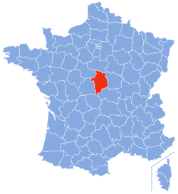
 Location of Cher in France | |
| الإحداثيات: 47°00′N 02°35′E / 47.000°N 2.583°E | |
| Country | فرنسا |
| Region | Centre |
| عاصمة الإقليم | Bourges |
| مراكز الدوائر | Saint-Amand-Montrond Vierzon |
| الحكومة | |
| • President of the General Council | Alain Rafesthain (PS) |
| المساحة | |
| • الإجمالي | 7٬235 كم² (2٬793 ميل²) |
| التعداد (1999) | |
| • الإجمالي | 314٬428 |
| • الترتيب | 70th |
| • الكثافة | 43/km2 (110/sq mi) |
| منطقة التوقيت | UTC+1 (CET) |
| • الصيف (التوقيت الصيفي) | UTC+2 (CEST) |
| Department number | 18 |
| الدوائر الادارية | 3 |
| Cantons | 35 |
| Communes | 290 |
| ^1 French Land Register data, which exclude estuaries, and lakes, ponds, and glaciers larger than 1 km2 | |
شير فرنسية: Cher: هو إقليم فرنسي تابع لمنطقة سانتر . أخذ امه من نهر شير . عد سكانه 315000 نسمة.
التاريخ
الجغرافيا
التعداد السكاني
السياسة
| Party | seats | |
|---|---|---|
| Union for a Popular Movement | 10 | |
| • | Socialist Party | 9 |
| • | French Communist Party | 7 |
| Miscellaneous Right | 5 | |
| • | Miscellaneous Left | 4 |
السياحة
The Bourges Cathedral of St. Étienne is a major tourist attraction.
انظر أيضاً
- Cantons of the Cher department
- Communes of the Cher department
- Arrondissements of the Cher department
المصادر
وصلات خارجية
- (بالفرنسية) General Council of Cher
- (بالفرنسية) Prefecture of Cher
- (إنگليزية) Cher at the Open Directory Project
- http://www.bc.edu/bc_org/avp/cas/fnart/arch/bourges.html
- http://www.sitesatlas.com/Europe/France/Bourges.htm
- http://berrichou.free.fr/
This article contains content from Wikimedia licensed under CC BY-SA 4.0. Please comply with the license terms.
