خالكيدونا
(تم التحويل من خلقيدونا)
Chalkidona
Χαλκηδόνα | |
|---|---|
 | |
| الإحداثيات: 40°44′N 22°36′E / 40.733°N 22.600°E | |
| البلد | |
| المنطقة الادارية | Central Macedonia |
| الوحدة المحلية | Thessaloniki |
| المساحة | |
| • البلدية | 391٫4 كم² (151٫1 ميل²) |
| • الوحدة البلدية | 130٫0 كم² (50٫2 ميل²) |
| المنسوب | 15 m (49 ft) |
| التعداد (2011)[1] | |
| • البلدية | 33٬673 |
| • كثافة البلدية | 86/km2 (220/sq mi) |
| • الوحدة البلدية | 8٬341 |
| • كثافة الوحدة البلدية | 64/km2 (170/sq mi) |
| Community | |
| • التعداد | 3٬094 (2011) |
| • المساحة (كم²) | 21.25 |
| منطقة التوقيت | UTC+2 (EET) |
| • الصيف (التوقيت الصيفي) | UTC+3 (EEST) |
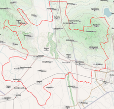
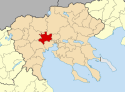
خالكيدونا (Chalkidona ؛ (باليونانية: Χαλκηδόνα)) هي بلدية في الوحدة المحلية سالونيك في اليونان. مقر البلدية هو بلدة كوفاليا.[2] The town is a hub for trucking traffic around the Thessaloniki area.
البلدية
The municipality Chalkidona was formed at the 2011 local government reform by the merger of the following 3 former municipalities, that became municipal units:[2]
- Agios Athanasios
- Chalkidona
- Koufalia
The municipality Chalkidona has an area of 391.4 km2, the municipal unit Chalkidona has an area of 130.0 km2, and the community Chalkidona has an area of 21.25 km2.[3]
المراجع
- ^ أ ب "Απογραφή Πληθυσμού - Κατοικιών 2011. ΜΟΝΙΜΟΣ Πληθυσμός" (in اليونانية). Hellenic Statistical Authority.
- ^ أ ب "ΦΕΚ A 87/2010, Kallikratis reform law text" (in اليونانية). Government Gazette.
- ^ "Population & housing census 2001 (incl. area and average elevation)" (PDF) (in اليونانية). National Statistical Service of Greece. Archived from the original (PDF) on 2015-09-21.
الكلمات الدالة:
This article contains content from Wikimedia licensed under CC BY-SA 4.0. Please comply with the license terms.


