مورطانيا القيصرية
| Provincia Mauretania Caesariensis | |||||||||||||
|---|---|---|---|---|---|---|---|---|---|---|---|---|---|
| مقاطعة الإمبراطورية الرومانية | |||||||||||||
| 42–القرن السابع | |||||||||||||
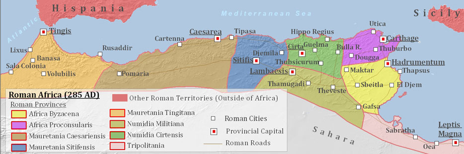
 مقاطعة ورمطانيا القيصرية داخل الامبراطورية الرومانية، ح. 120 م. | |||||||||||||
| العاصمة | قيصرية | ||||||||||||
| التاريخ | |||||||||||||
| العصر التاريخي | العتيق الكلاسيكي | ||||||||||||
• Established | 42 | ||||||||||||
• الفتح الإسلامي | القرن السابع | ||||||||||||
| |||||||||||||
| اليوم جزء من | |||||||||||||
| جزء من سلسلة مقالات عن |
| تاريخ الجزائر |
|---|
 |
مورطانيا القيصرية Mauretania Caesariensis، كانت مقاطعة رومانية تقع في شمال غرب أفريقيا. وكانت أكثر المقاطعات الرومانية شرقاً في شمال أفريقيا، في الجزائر المعاصرة، وكانت عاصمتها قيصرية (وعلى اسمها سميت المقاطعة؛ من بين مدن كثيرة سميت على اسم الكنية الامبراطورية الذي أصبح لقباً)، شرشال حالياً.
The province had been part of the Kingdom of Mauretania and named for the Mauri people who lived there. Formerly an independent kingdom, and later a client state of Rome, it was annexed into the Empire formally during the reign of Claudius and divided into two provinces about 42 AD. A third province, named Mauretania Sitifensis, was later split off from the eastern portion during the reign of Diocletian in 293 AD. During and after the fall of the Western Roman Empire in the 5th century, most of the hinterland area was lost, first to the Vandal Kingdom and later to the Mauro-Roman Kingdom, with Roman administration limited to the capital of Caesarea. The land was reconquered by Rome during the reign of Justinian. This province was a part of Praetorian prefecture of Africa, later Exarchate of Africa. The Muslim conquest of the Maghreb brought an end to Roman rule in Mauretania, permanently this time, which became ruled by the Umayyad Caliphate as part of Medieval Muslim Algeria.
التاريخ


In the middle of the 1st century, Roman emperor Claudius divided the westernmost Roman province in Africa, named Mauretania ('land of the Mauri', hence the word Moors), into Mauretania Caesariensis (named after its capital, Caesarea in Mauretania, one of many cities named Caesarea after the imperial cognomen that had become a title) and Mauretania Tingitana.
Mauretania Caesariensis included eight colonies founded by the Emperor Augustus: قرتينة، Gunugus, Igilgili, Rusguniae, Rusazus, Saldae, Zuccabar, Tubusuctu; two by the Emperor Claudius: Caesarea in Mauretania, formerly the capital of Juba II, who gave it this name in honour of his patron Augustus, and Oppidum Novum; one by the Emperor Nerva: Setifis; and in later times, Arsenaria, Bida, Siga, Aquae Calidae, Quiza Xenitana, Rusucurru, Auzia, Gilva, Icosium and Tipasa in all 21 well-known colonies, besides several municipia and oppida Latina.
Under Diocletian's Tetrarchy reform, the easternmost part was broken off from Mauretania Caesariensis as a separate small province, Mauretania Sitifensis, called after its inland capital Setifis (now Sétif) with a significant port at Saldae (presently Béjaïa).[1]
At the time of Diocletian and Constantine the Great, both Sitifensis and Caesariensis were assigned to the administrative Diocese of Africa, under the Praetorian prefecture of Italy. Tingitana belonged to the Diocese of Hispania under the Praetorian prefecture of Gaul, so it was an enclave separate from the European territory of the Diocese and Prefecture it belonged to.
After the fall of the Western Roman Empire, a Germanic Vandal Kingdom was founded, but the remaining Eastern Empire (now known to historians as the Byzantine Empire) recaptured the area around 533. Most of Mauretania Caesariensis remained under the control of local Moorish rulers such as Mastigas, and it was not until the 560s and 570s that Byzantine control was established inland.
During the reign of Maurice, the empire was reorganized, and a number of Exarchates were founded, among them the Exarchate of Africa, which included Mauretania, among other territories. Mauretania Sitifensis was re-merged back into this province and granted the name "Mauretania Prima."
The Muslim conquest of the Maghreb for the caliphate under the Umayyad dynasty meant the end of the Byzantine Exarchate of Africa and Late Antique Roman culture there, and Mauretania Caesariensis became part of the westernmost Islamic province called Maghreb.[بحاجة لمصدر]
الاقتصاد

The principal exports from Caesariensis were purple dyes and valuable woods; and the Amazigh or Mauri were highly regarded by the Romans as soldiers, especially light cavalry. They produced one of Trajan's best generals, Lusius Quietus, and the emperor Macrinus.

الدين
الكراسي الرسولية
- Ala Miliaria
- Albulae
- Altava (ولد ميمون، حجر الروم)
- Amaura
- Ambia (near Hammam-Bou-Hanifia)
- Aquae in Mauretania
- Aquae Sirenses (ruins at Hammam-Bou-Hanifia)
- Arena (Bou-Saada?)
- Arsennaria (Bou-Râs?)
- Auzia (Aumale, Sour-Khazlam)
- Bacanaria
- Baliana (L'Hillil?)
- Bapara (near the promontory of Ksila?)
- Benepota
- Bida (ruins of Djemâa-Sahridj?)
- Caesarea in Mauretania
- Caltadria
- Capra
- Caput Cilla (ruins of El-Gouéa?)
- Cartennae
- Castellum Ripae (ruins of Hadjar-Ouaghef?)
- Castellum Tatroportus
- Castellum Tingitii
- Castellum Iabar
- Castellum Medianum
- Castellum Minus (Coléa, near Algiers)
- Castra Nova
- Castra Severiana (Lalla Marnia? Chanzy, Sidi-Ali-Ben-Joub?)
- Catabum Castra (Saint-Aimé, Djidioua?)
- Catrum
- Catula (Oued Damous?)
- Cenae (Kenais Islands)
- Cissi
- Columnata
- Corniculana
- Elephantaria in Mauretania (ruins at Harrach)
- Fallaba (Djelfa?)
- Fidoloma
- Flenucleta
- Floriana (Letourneux, Derrag?)
- Flumenzer (Bou Medfa)
- Fronta
- Giru Mons (ruins of Yerroum?)
- Gratianopolis
- Gunugus (Sidi-Brahim)
- Gypsaria (Honeïn)
- Ida in Mauretania
- Igilgilli (in the valley of Bou-Sellam?)
- Iomnium (Tzigiri)
- Ita
- Iunca in Mauretania
- Lamdia
- Lari Castellum (Imilaën)
- Maiuca
- Malliana
- Manaccenser (in the region of Cherchell)
- Masuccaba
- Maturba
- Maura (Douelt-Zerga?)
- Mauriana
- Maxita (in the region of Al-Asnam?)
- Media
- Mina (ruins near Rezilane)
- Muteci (near Aïn-El-Anab?)
- Nabala
- Nasbinca
- Noba
- Novica (ruins of Aïn-Nouïssy?)
- Numida (in the territory of Amoura)
- Obbi
- Obori
- Oppidum Novum
- Panatoria
- Pomaria
- Rapidum (Masqueray, Sour-Djouab)
- Regiae (Arbal)
- Reperi
- Rusada
- Rusguniae
- Rusubbicari
- Rusubisir (in the territory of Tiza)
- Rusuccuru
- Satafi
- Sereddeli
- Serta
- Sesta
- Sfasferia
- Siccesi (ruins of Takembrit)
- Sinnada in Mauretania (ruins of Kenada?)
- Sita (in the west of the province
- Subbar
- Sufar
- Sufasar
- Summula
- Tabaicara
- Tabla (Tablat?, Tablast?)
- Taborenta (ruins near Saida?)
- Tabunia
- Tamada (Aïn-Tamda near Masqueray?)
- Tamazuca (ruins of Grimidi?)
- Tanaramusa (Mousaïaville, El-Hadjeab? Berrouaghia?)
- Tasaccora (Sigi)
- Tatilti
- Tigamibena
- Tigava
- Tigisi in Mauretania (between Dellys and Taourga)
- Timici (Timsionin?)
- Timidana
- Tingaria (Tiaret?)
- Tipasa in Mauretania
- Tubia (ruins of Henchir-Toubia?)
- Tubunae in Mauretania
- Turris in Mauretania
- Tuscamia
- Ubaba
- Usinaza (Seneg)
- Vagal (near the ruins of Sidi-Ben-Thiour)
- Vanariona (ruins of Ksar-Tyr?)
- Vannida
- Vardimissa (near Medjana)
- Villa Nova
- Vissalsa (on the Oued-Melah river?)
- Voncaria (ruins of Boghar?)
- Voncariana (near the ruins of Boghasi?)
- Vulturia (ruins at the Falco promontory?)
- Zucchabar
انظر أيضاً
المصادر
- ^ "Map of Mauretania Sitifensis (in blue color) and Mauretania Caesariensis (in light brown color)". Archived from the original on 2017-02-02. Retrieved 2017-10-11.
المراجع
- Westermann, Großer Atlas zur Weltgschichte (بالألمانية)

- Short description is different from Wikidata
- Former country articles requiring maintenance
- Pages using infobox former subdivision with unknown parameters
- Articles with unsourced statements from May 2019
- مقاطعات رومانية قديمة
- مقاطعات الامبراطورية البيزنطية
- تاريخ موريتانيا
- تاريخ مورطانيا
- دول وأراضي تأسست في القرن الأول
- مورطانيا القيصرية
- مقاطعات رومانية متأخرة
- تأسيسات القرن الأول في الامبراطورية الرومانية