چروم
(تم التحويل من Çorum)
Çorum | |
|---|---|
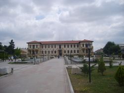
 المتحف الأثري في چروم | |
 | |
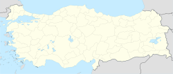
| الإحداثيات: 40°33′00″N 34°57′14″E / 40.55000°N 34.95389°E | |
| البلد | تركيا |
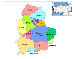
| المحافظة | چروم |
| الحكومة | |
| • Mayor | Muzaffer Külcü (AKP) |
| المساحة | |
| • District | 2٬276٫81 كم² (879٫08 ميل²) |
| التعداد (2012)[2] | |
| • Urban | 231٬146 |
| • District | 265٬242 |
| • كثافة District | 120/km2 (300/sq mi) |
| الموقع الإلكتروني | www.corum.bel.tr |
مدينة تشوروم (تركية: Çorum؛ النطق التركي: []) هي عاصمة محافظة شوروم في منطقة البحر الأسود بتركيا. ويبلغ عدد سكانها 161,321 تقع على مسافة 244 كم من أنقرة و 608 كيلومترا من اسطنبول.
تشوروم اليوم
| تعداد سكان مدينة چروم | |
|---|---|
| 2009 | 206,572 |
| 2000 | 161,321 |
| 1990 | 116,810 |
| 1985 | 96,725 |
| 1980 | 75,726 |
| 1970 | 57,576 |
| 1960 | 34,726 |
المناخ
چروم تتسم مناخ قاري دافئ جاف صيفاً (تصنيف كوپن للمناخ: Dsb) with dry summers and cold, snowy winters, and mild to cool wet springs and autumns with light rain.
| بيانات المناخ لـ چروم | |||||||||||||
|---|---|---|---|---|---|---|---|---|---|---|---|---|---|
| الشهر | ينا | فب | مار | أبر | ماي | يون | يول | أغس | سبت | أكت | نوف | ديس | السنة |
| متوسط القصوى اليومية °س (°ف) | 4.2 (39.6) |
6.2 (43.2) |
11.6 (52.9) |
17.4 (63.3) |
22.0 (71.6) |
25.9 (78.6) |
29.0 (84.2) |
29.3 (84.7) |
25.6 (78.1) |
19.7 (67.5) |
12.6 (54.7) |
6.4 (43.5) |
17.5 (63.5) |
| المتوسط اليومي °س (°ف) | −0.4 (31.3) |
0.9 (33.6) |
5.1 (41.2) |
10.5 (50.9) |
14.8 (58.6) |
18.5 (65.3) |
21.1 (70.0) |
21.0 (69.8) |
17.0 (62.6) |
11.8 (53.2) |
5.9 (42.6) |
1.9 (35.4) |
10.7 (51.2) |
| متوسط الدنيا اليومية °س (°ف) | −4.3 (24.3) |
−3.7 (25.3) |
−0.6 (30.9) |
3.8 (38.8) |
7.3 (45.1) |
10.2 (50.4) |
12.4 (54.3) |
12.3 (54.1) |
9.0 (48.2) |
5.2 (41.4) |
0.7 (33.3) |
−1.9 (28.6) |
4.2 (39.6) |
| متوسط تساقط الأمطار mm (inches) | 38.4 (1.51) |
30.4 (1.20) |
37.8 (1.49) |
52.6 (2.07) |
60.2 (2.37) |
54.3 (2.14) |
20.3 (0.80) |
14.4 (0.57) |
22.7 (0.89) |
29.9 (1.18) |
36.6 (1.44) |
47.2 (1.86) |
444.8 (17.52) |
| Average rainy days | 11.7 | 10.7 | 11.7 | 12.9 | 13.9 | 10.3 | 4.3 | 3.2 | 4.7 | 7.8 | 9.0 | 11.8 | 112 |
| Mean monthly ساعات سطوع الشمس | 77.5 | 98 | 151.9 | 186 | 238.7 | 273 | 316.2 | 313.1 | 252 | 176.7 | 111 | 65.1 | 2٬259٫2 |
| Source: Devlet Meteoroloji İşleri Genel Müdürlüğü [3] | |||||||||||||
انظر أيضاً
الهامش
- ^ "Area of regions (including lakes), km²". Regional Statistics Database. Turkish Statistical Institute. 2002. Retrieved 2013-03-05.
- ^ "Population of province/district centers and towns/villages by districts - 2012". Address Based Population Registration System (ABPRS) Database. Turkish Statistical Institute. Retrieved 2013-02-27.
- ^ http://www.dmi.gov.tr/veridegerlendirme/il-ve-ilceler-istatistik.aspx?m=CORUM
وصلات خارجية
This article contains content from Wikimedia licensed under CC BY-SA 4.0. Please comply with the license terms.


